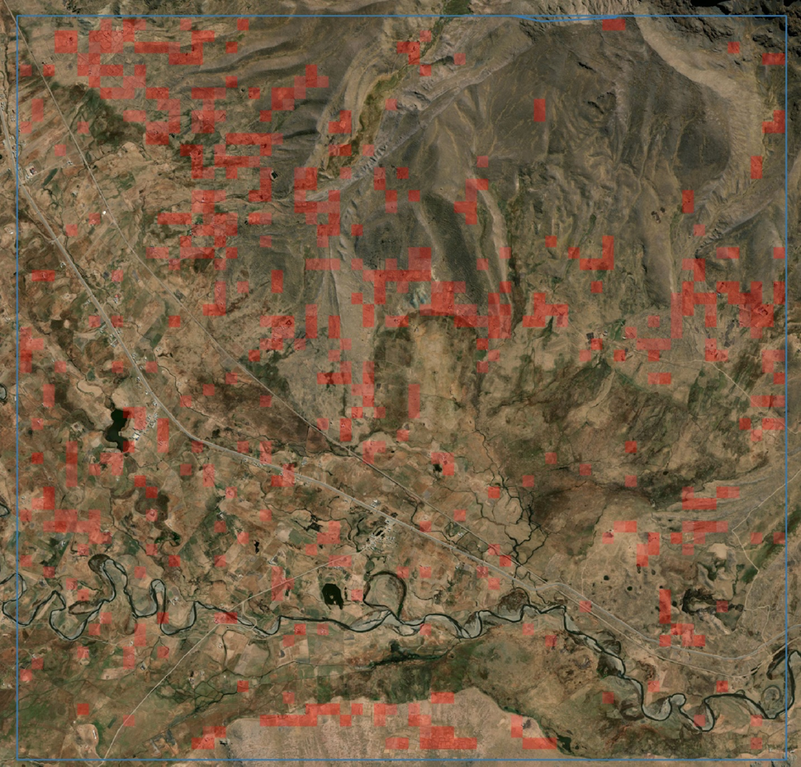
Professor Steven Wernke’s groundbreaking archaeological mapping project has secured its most substantial funding yet: a $625,000 grant from the National Science Foundation. Using satellite imagery and artificial intelligence, Wernke and his team are mapping archaeological sites across the Andes Mountain Range to build a detailed inventory that will improve our understanding of Andean settlement systems and human-modified landscapes.
“Until now, even the largest field-based archaeological surveys—efforts taking over a decade—have covered areas roughly the size of a couple of counties,” Wernke explained. “While archaeologists excel at detailed mapping and understanding small-scale contexts, we’ve lacked comprehensive data on the regional distribution of archaeological sites—and that has limited our understanding. We finally have the tools we need to better understand broader patterns of human settlement and land use.”
This latest award builds upon the project’s previous successes, which were fueled by two earlier investments. In 2022, Wernke’s team received a Scaling Success grant from the university’s Office of the Vice Provost for Research and Innovation.
“I am so grateful for the support of University Vice Provost for Research and Innovation Padma Raghavan and her Scaling Success program,” Wernke said. “I honestly don’t think I could have developed these projects and had success with the NEH and NSF grants so quickly without that support.”
The Scaling Success grant helped pave the way for Wernke’s team to secure a $350,000 NEH grant in 2023. That funding enabled the team to expand its survey site by 10 times to include the Central Andes, an area of about 700,000 square kilometers. The NSF grant will stretch the area to encompass all of the Andes—an area of about 2 million square kilometers, spanning Ecuador, Peru, Bolivia, Argentina and Chile.
Radical collaboration unlocks Andean secrets with high-tech approach
After 25 years of field archaeology in close collaboration with host communities, Wernke dreamed of a massive image-based archaeological survey that could systematically document how archeological sites interconnect, and thus improve understanding of human migration and evolution across a vast landscape.
To achieve the necessary scale, the team needed an AI model that could “see” probable archaeological features (specifically animal corrals and abandoned structures), but Wernke was not yet proficient with the technology. Then, during the first artificial intelligence training event hosted by the Vanderbilt University Data Science Institute in 2018, Wernke met Yuankai Huo, assistant professor of computer science and electrical and computer engineering, who is also affiliated with The Vanderbilt Lab for Immersive AI Translation.

“DSI and VALIANT provide a unique collaborative environment and opportunities for scientists from various fields at Vanderbilt, facilitating this multidisciplinary collaboration. DSI’s recent investment in DGX box high-performance GPU servers has been crucial in enabling us to train large-scale, multidisciplinary AI foundation models, which was computationally infeasible for my lab,” Huo said.
“During that event, we had a breakthrough moment,” Wernke said. “I realized what I needed was an object detection solution, and Dr. Huo’s expertise in super high-resolution computer vision was the key. His work was already enhancing the detection of anomalies in human tissue, such as cancer cells, on histological images. We saw the parallel in archaeology—we faced a similar problem of detecting small, discrete features made of the same materials as the surrounding landscape matrix. It was a perfect match of expertise across disciplines.”
Wernke, Huo and Wernke’s longtime collaborator, Brown University anthropologist Professor Parker VanValkenburgh (who is principal investigator on a linked NSF grant for the same project) worked with Bennett Landman, Stevenson Chair of Electrical and Computer Engineering, chair of the Department of Electrical and Computer Engineering and director of VALIANT, to integrate AI with GeoPACHA and teach the model to detect probable archaeological sites.
Survey will reveal trade routes, migration patterns throughout the Andes Mountains
The $625,000 NSF grant not only dramatically expanded the survey area, it also funds immersive learning experiences for students, who will work with six teams of archaeologists as they audit the AI-detected archaeological sites. “In this AI-assisted framework, the AI does much of the tedious work of initial survey, while we rely on regional experts to correct and enrich the data with their contextual observations,” Wernke said.
The last step in the Andres survey project will be the creation and sharing of curated data sets that will be released as open-source software. The team believes that the information will prove invaluable for other areas of scientific research, including climate change, biodiversity and structural geology.
“This research is really important for our understanding of human history. We only have one pass through human history to document the archaeological record, which, after all, will eventually succumb to degradation through time. We are connecting the dots that are forming a more accurate and complete picture of how indigenous peoples were connected through vast settlement networks, and how they both adapted to and transformed their landscapes.”