A $350,000 grant to develop next-generation archaeological mapping technology will let a Vanderbilt-led research team reveal information about vast settlement systems and human-modified landscapes in the Andes.
Steven Wernke, associate professor and chair of the Department of Anthropology, is the project director of the research initiative, which will result in the largest archaeological imagery survey in the Western Hemisphere. This three-year NEH Digital Advancement Grant will fund the development of Geospatial Platform for Andean Culture, History and Archaeology, or GeoPACHA 2.0.
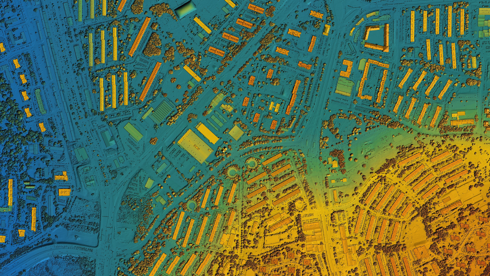
Wernke’s original GeoPACHA 1.0 was funded by previous NEH and American Council of Learned Societies grants, which laid the foundation for this next phase of AI-assisted survey. The new version of the browser-based geographic information system will offer a continuous view of human settlement and human landscapes across more than 600,000 square kilometers in the central Andes. It will develop and deploy AI to identify archaeological features in high-resolution satellite imagery and corresponding historical aerial photos. After its codebase and deep learning models are refined to detect archaeological features, GeoPACHA will become the tech-enabled way that archaeologists and anthropologists can newly envision the fuller context of past societies across the continent.
“We archaeologists tend to be quite good at understanding human stories at the scale of households, villages or even cities and regions, but we struggle to grasp the big picture of how human societies were connected over vast areas,” Wernke said. “Archaeologists have traditionally peered into the past through the small keyholes of our excavations and field surveys, which are not evenly or systematically distributed over the landscape. That makes it hard to understand how representative our views of past social worlds are.”
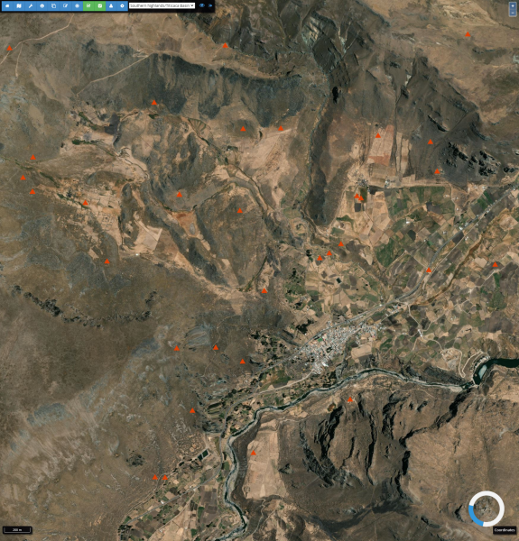
GeoPACHA has already identified about 40,000 archaeological loci in six survey zones throughout the central Andes using manual visual survey of satellite imagery. With the next phase of research, GeoPACHA 2.0 will integrate AI to zero in on areas with probable archaeological features, enabling dramatic upscaling of survey coverage to encompass all of the central Andes. Built at Wernke’s Spatial Analysis Research Laboratory (which houses the Vanderbilt Institute for Spatial Research), GeoPACHA has already yielded valuable insights into human social dynamics across time and distances.
“This project exemplifies the transformative research that arises from the convergence of collaboration, innovation and cutting-edge technology,” said C. Cybele Raver, provost and vice chancellor for academic affairs.
Wernke is conducting the geospatial modeling and analysis with Assistant Professor of Computer Science and Electrical Engineering Yuankai Huo and his graduate student team, undergraduate anthropology students, postdoctoral fellow James Zimmer-Dauphinee, researchers at the Data Science Institute and a Brown University team led by Parker VanValkenburgh.

“Our team of undergraduate researchers spent hundreds of hours carefully recording the locations of archaeological features in satellite imagery by hand. Now, we are using that data to train deep learning models, which can be deployed on new imagery to identify the locations of unrecorded features,” Zimmer-Dauphinee said. “It’s a dynamic conversation between the AI and the researchers that will let us explore the landscape at scales that are otherwise unmanageable.”
After the AI improvements to GeoPACHA, diverse, international teams of regional experts and their students will audit and add observational data to the features captured by the autonomous technology. Vanderbilt students are also learning the immense power of linking augmented intelligence to questions in archaeology as they work on their immersion projects with Wernke in his lab.
“Throughout our development of GeoPACHA, we have been collaborating closely with host institutions and colleagues in Andean countries,” Wernke said. “We will continue to develop AI models of interest to them for research and for cultural heritage management priorities.”
“Comprehending the interconnectedness of past human societies across such expansive regions demands cutting-edge image processing and computer vision technologies. Collaborating across multiple disciplines has been a thrilling and gratifying experience,” Huo said.

Wernke and Huo’s work was bolstered by a Scaling Success Grant from Vanderbilt. “Being awarded this NEH grant underscores how Scaling Success Grants empower faculty to amplify the impact of their research, enabling them to secure larger and more competitive awards from federal, foundation and industry sponsors,” Huo said.
Wernke’s grant is one of fewer than 300 funded projects from the NEH’s third and final funding round for fiscal year 2023. It is the only project to be funded in Tennessee this cycle. Wernke’s research is also supported by Research Development and Support.
About Research Development and Support
The office of Research Development and Support offers proposal development assistance for private (foundations) and federally funded opportunities. Services for Vanderbilt faculty include searches for new sponsors, coordination and team building for proposals of any size, content development and draft review. RDS further supports faculty by building relationships with external sponsors, hosting workshops and providing guides and language for common proposal requirements. RDS is in the Office of the Vice Provost for Research and Innovation. To learn more about RDS or request services, email rds@vanderbilt.edu.