In order to reconstruct how the Earth’s climate has changed in the past – knowledge that is essential to understand how it will change in the future – climate scientists rely on a broad range of indirect methods called proxies, including tree rings, ice cores, sediment cores, records of ancient lake levels, changes in the size and position of glaciers and variations in the chemical composition of stalagmites in caves, to name a few.
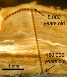
One of the more plebian proxies consists of gravel and pebbles covered with soil in arid and semi-arid areas that are slowly coated in microscopic layers of the mineral carbonate. Climate scientists call them “pedothems.” Their major advantage is that they are quite common in inhabited locations. Their major disadvantage has been the low resolution of the data that they produce because the coating is so thin, measuring as little as 3 millimeters in thickness.
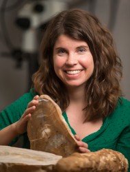
Now a team of scientists including Assistant Professor of Earth and Environmental Sciences Jessica Oster has published a paper in the Proceedings of the National Academy of Sciences that reports a new micro-analytic method that can be applied to pedothems to produce data on local variations in temperature and precipitation at thousand-year intervals over the last 100 thousand years.

“The ability to get such high-resolution information from pedothems will improve the accuracy and resolution of our climate reconstructions in a number of important regions, including the Western United States,” said Oster.
The new techniques, which use both lasers and ion beams much like tiny dental drills to obtain microscopic samples for analysis was pioneered by Erik Oerter, a post-doctoral research fellow at the University of Utah.
The information that these layers contain is based on the ratios of the isotopes of several key elements. (Isotopes are atoms that have identical chemical properties but differ slightly in mass.) By comparing ratios of the isotopes of radioactive elements including uranium and thorium, scientists could determine the age of the carbonate layers with remarkable precision. In addition, the ratio of uranium isotopes provided them with a good proxy for the total amount of rainfall that fell as each layer was formed.
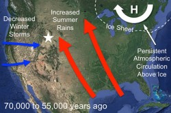
Another key proxy was the ratio between oxygen isotopes – O16 and O18. Storms that originate in the Gulf of Mexico have a different oxygen isotope ratio that those coming from the Pacific so this ratio provided information about the rainfall’s origin. Oster, who specializes in studying cave structures as paleoclimate proxies, helped work out the chronology of the pedothem oxygen isotope records.

The team of earth scientists demonstrated the value of this approach by analyzing a group of pedothems they collected in Wyoming. Their analysis revealed that between 70,000 and 55,000 years ago – in the middle of minor ice age – the precipitation pattern in North America was dominated by a south-to-north flow from the Gulf of Mexico instead of the familiar west-to-east flow from the Pacific. This circulation pattern translated into wetter and summers and drier winters in central North America.
“The cool thing that this study reveals is that within soil – an unlikely reservoir given how ‘messy’ most people think it is – there is a mineral that accumulates steadily and creates some of the most detailed information to date on the Earth’s past climates,” said senior author Ronald Amundson, professor of environmental science, policy and management at UC Berkeley.
Related Information:
- UC Berkeley News Release
- Pedothem carbonates reveal anomalous North American atmospheric circulation 70,000–55,000 years ago (Article in Proceedings of the National Academy of Science)
- Deciphering clues to prehistoric climate changes locked in cave deposits
- A VU Inside: Professor explores caves for clues to climate change