Locke Island is a small island in a bend of the Columbia River in eastern Washington that plays a special role in the culture of the local Indian tribes. Since the 1970s, however, it has been eroding away at a rate that has alarmed tribal leaders.
The island is part of the Hanford Reservation, which is managed by the Department of Energy. So the DOE has turned to a team of researchers headed by David Furbish, professor of earth and environmental sciences (E&ES) at Vanderbilt, to study the river dynamics in the area to identify the cause of the increase in erosion and provide the scientific basis for evaluating the effectiveness of possible remedial measures.
As part of this effort, E&ES major Grace Loy has been conducting small-scale tests of the river flow around the island using a stream table, and graduate student John Roseberry is incorporating the results of these tests into a more detailed computer simulation. Loy presented the initial results of their study Dec. 16 in a poster paper at the annual meeting of the American Geophysical Union in San Francisco.
Locke Island’s difficulties began when the east bank of the river adjacent to it began to collapse. The resulting landslide continued to grow for the next 20 years, increasingly pinching down the channel that flows around that side of the island. Concern over the impact that this was having on the island prompted scientists at DOE’s Pacific Northwest National Laboratory to begin monitoring the situation in 1994. According to their records, as much as 120 feet of the island bank facing the landslide eroded away between 1996 to 2006, peaking in 1997 during a period of unusually high river flow. Another episode of erosion took place during high flows in 2002. However, the landslide has not grown since 1998 when ponds on the bluff above thought to be responsible were drained.
[rquote]“The generally accepted explanation for the increased erosion has been that the narrowing of the channel forced the water flowing through it to speed up significantly and the stronger current wore away the side of the island more rapidly[/rquote],” Loy said. “We were skeptical of this explanation and our analysis suggests that it isn’t what happened.”
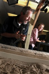
The stream table consists of a straight wooden channel with a large tank of water at one end. A mockup of the island and the landslide sit halfway down. Bright lights and a video camera are aimed down on the channel from above. A test consists of running water at different velocities down the channel and dropping small green beads into the water at the top of the channel. As the beads are carried down the channel their motion is recorded by the video camera. The images are then analyzed by computer to map the velocity of the currents at different locations.
“When we add the landslide, we find that the water builds up in front of the narrow channel and this steers much of the water into the larger channel,” Loy said. As a result, instead of flowing at the same speed in the large channel and flowing much more rapidly in the narrow channel, the current in both channels increases slightly compared to what it was before the landslide.
[lquote]“We predicted this steering effect but it was much larger than we expected in our tests.[/lquote] The flow was about 50/50 between the two channels without the landslide. With the landslide it was as high as 75/25 percent,” Loy said.
Furbish cautioned that they cannot yet conclude that this is exactly what is happening on the river: There are certain aspects of the stream-table studies that cannot be scaled up. So they must wait for the completion of the computer simulations expected in the next six months before they can estimate how strong this steering effect is on the river itself.
The Vanderbilt team was recruited for the study by the Consortium for Risk Evaluation with Stakeholder Participation, a multi-university consortium led by Vanderbilt and funded by DOE to work with stakeholder groups to develop cost-effective and politically acceptable methods for cleaning up the nation’s nuclear weapons production sites.
“Since I was a boy, I have admired Native Americans,” Furbish said. “So it is very exciting to be working on a project that can help them protect land that is special to them.”