Climate scientists now put the odds that the American Southwest is headed into a 30-year “mega drought” at 50/50. Meanwhile, the forecast for the Pacific Northwest is continued warming with slightly drier summers and even wetter winters.
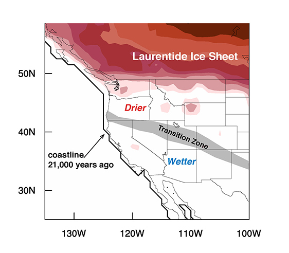
However, 21,000 years ago, at the peak of the last Ice Age, a period known as the Last Glacial Maximum, the Southwest was wetter than it is today – much wetter – and the Northwest was drier – much drier.

A team of scientists from Vanderbilt and Stanford universities have created the first comprehensive map of the topsy-turvy climate of the period and are using it to test and improve the global climate models that have been developed to predict how precipitation patterns will change in the future. Their efforts are described in a paper published online on Feb. 23 by the journal Nature Geoscience.
“Most of the previous research of the past climate in this region is based on detailed studies of specific sites,” said primary author Jessica Oster, assistant professor of earth and environmental sciences at Vanderbilt University. “We combined these records to create a detailed map of past climate change in the American West. We then compared this map to computer climate models to understand what caused these changes.”
“Our previous research used field studies to understand the history of climate change in the Western U.S.,” said study coauthor Kate Maher, assistant professor of geological and environmental sciences at Stanford University. “It was amazing to see how our results, when combined with work of many other research groups and compared to the newest generation of climate models, revealed a consistent story about how rainfall patterns were altered in the past.”

One of the reasons that Oster and her colleagues picked this region to map is because the mid-latitudes, in general, and the western United States, in particular, are regions where the climate models tend to disagree on the magnitude and, in some cases, even the direction that precipitation patterns will change in the future.
“This is a transition zone. There are strong competing effects such as changes in the large-scale atmospheric circulation, sea surface temperature changes like El Niño and La Niña and the dynamics of westerly storm tracks that all interact at the mid-latitudes,” said co-author Matthew Winnick who contributed to the study along with fellow Stanford doctoral student Daniel Ibarra. “As a result, understanding the exact nature of how these different effects express themselves to form the north/south transition zone will be extremely important for freshwater resource management in major population centers across the Western U.S.”

Of course, there aren’t any direct records of precipitation levels thousands of years ago. So climate scientists rely on indirect means, called proxies, to reconstruct past variations in precipitation patterns. In this case, the researchers combined records of ancient lake levels, location and extent of glaciation, variations in the composition of stalagmites in caves, and evidence for changes in vegetation and subsurface soil deposits associated with water table depth. (One of the smelliest proxies that they used is pollen preserved in ancient packrat middens).

During the Last Glacial Maximum, Canada was completely inundated by the massive Laurentide Ice Sheet. A number of the site-specific studies in the Northwest had provided evidence for a drier climate during the period, while similar studies in the Southwest found evidence for a wetter climate. For instance, a 1997 vegetation study from the University of Wisconsin found that much of the Northwest was covered by polar desert or tundra while the Southwest was covered by extensive conifer and broadleaf forest. However, there was also conflicting evidence of drier conditions at some sites in Utah and Colorado and of wetter conditions in Idaho and Montana.
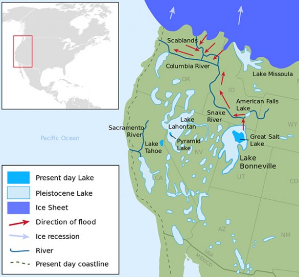
“People hypothesized that the transition between the two climate zones ran long a straight east-west line, but that didn’t work very well,” said Oster. “Our study indicates that the transition zone is angled from the northwest to the southeast.” This explains the drier conditions in Utah and Colorado. Their analysis also found that the wetter sites in the north were situated next to large inland lakes that existed at the time, so they attribute them to local, lake effects.
Two basic theories have been advanced to explain the dramatically different rainfall patterns of this period:
- One is that the cold air above the Laurentide Ice Sheet created a tremendous high pressure system that shifted the polar jet stream to the south, pushing the track followed by winter storms down into the Southwest, which had the effect of dramatically reducing the amount of rainfall in the Northwest while increasing it in the Southwest.
- An alternative explanation is that the subtropical jet stream was enhanced, increasing the frequency with which the Southwest was hit by “Pineapple Expresses:” water-saturated subtropical plumes of air that periodically swing up from Hawaii and hit the West Coast and these days cause serious flooding. When combined with a strengthened summer monsoon, this could also explain the wetter conditions in the Southwest.
When the researchers compared their results with the output of a number of climate models, they found that several of the newer models that have higher resolution and use updated ice sheet configurations do “a very good job” of reproducing the patterns observed in the proxy records.
“According to these models, it is the high pressure cells that are really important in steering winter storms, and in determining the shape and location of the transition zone,” said Oster. “Some models do hint at an increase in subtropical winter moisture, but we don’t see evidence of an enhanced summer monsoon.”
Given the prospect of continued global warming, there is no chance that this ancient weather pattern will return in foreseeable future. Curiously, however, a similar pattern re-emerges periodically during the warm phase of the El Nińo–Southern Oscillation, which produces drier than normal winters in the Northwest and wetter than normal winters in the Southwest.
The research was supported by National Science Foundation grants AGS1203701 and EAR0921134.